About GEMFIND
A faithful modern web port of a 1997 Australian shareware program.
GEMFIND was a Visual Basic 3.0 program released by
Michael Paine in
December 1997 as AU$40 shareware. It plotted Australian gemstone
fossicking locations on a symbolic, scalable map of Australia. The
original ran under Windows 3.1, shipped as a self-extracting
GEMZIP.EXE from his Australian Open Access User Group
page, fit in under 500 KB installed, and was hand-maintained from
a Microsoft Access database that Michael "reluctantly" used to keep
the data tidy.
This site is an unaffiliated tribute port. It plots the same ~290 locations Michael compiled, against a modern basemap, with the same bidirectional gemstone↔town filter that was the soul of the original. No new fossicking locations have been added. No permit info, no community contributions, no accounts.
The reference book
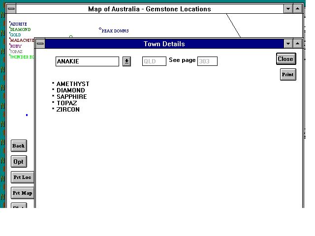
Every location in GEMFIND carries a PAGE# field
pointing into the locality directory of:
Myatt, Bill (ed.). How and Where to Find Gemstones in Australia and New Zealand. Lansdowne Press, Sydney. Revised edition 1987, reprinted 1991. 486 pages. ISBN 0701816686.
The book's locality directory occupies roughly pages 269–400, organised by state. The "Originally referenced in Myatt 1987, p. 303" footnote in each locality popover refers to that book. Roughly two-thirds of GEMFIND localities have a page reference; Michael's own footnote in the original program noted that many of his entries weren't in the book's index at all.
The DMT grid
Michael's coordinate system isn't a standard projection. Reading the
transcribed 1997 README,
he explains it as the "DMT grid" — derived from work he did with
Owen Johnstone at the NSW Department of Motor Transport ~20 years
before 1997, mapping vehicle roadworthiness inspections in HPL on
Hewlett-Packard hardware. It gives South Australia and Western
Australia negative X values and Tasmania negative Y values, and it
is preserved in the modern dataset as the
original_x/original_y fields on every
locality.
The plotted dots on this site use modern coordinates geocoded from
the GeoNames Australia
gazetteer (CC BY 4.0). Michael's grid is kept for provenance
and is used as a sanity check when matching town names. Where
GeoNames has nothing — about a dozen small mining sites — the
original grid coordinate is the only thing we have, and the
locality is left off the map for now with a
needs_review flag.
Five gemstones without entries
The selector rail shows five gemstones in muted text with no count:
Amber, Chalcedony, Corundum, Geodes, and
Tourmaline. These exist as entries in Michael's
gemstone reference table (GEMSTONE.DAT in the original
binaries) but have no fossicking-location records in his join
table. Reasons vary:
- Corundum is the species; Australian fossickers list its gem-quality varieties (Sapphire, Ruby) instead.
- Chalcedony covers a whole family; its varieties (Agate, Chrysoprase, Jasper) carry the location records.
- Amber, Geodes, Tourmaline are uncommon enough in Australian fossicking that Michael never recorded a specific locality for them.
They appear in the rail because faithfulness to the original program matters more than tidiness, and because their descriptions are still useful background.
The 1997 program, in screenshots
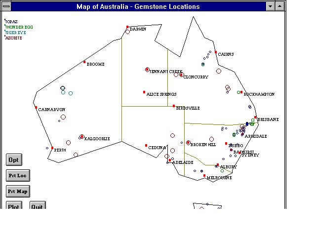
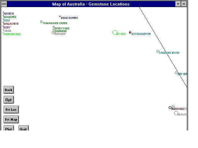
The concentric-circles visualisation Michael describes in his README — "locations rich in gemstone variety stand out by their multicoloured concentric circles" — lives on in this port as the petal/Venn cluster you see at every multi-gemstone locality.
Attribution
- Data, design, and the original program: © Michael Paine, 1997.
- Reference book locality entries: Myatt 1987, as cited above.
- Modern basemap tiles: OpenFreeMap, OpenMapTiles, OpenStreetMap contributors.
- Geocoding: GeoNames AU dump (CC BY 4.0).
- Modern port and editorial decisions: see Data and the included
CHANGES.md.